Cooling the Capital: Analyzing the Effect of Tree Canopy Coverage in Reducing Land Surface Temperatures in Washington, D.C. during Heatwaves
Abstract
Between June 2023 and June 2025, the District of Columbia’s mayor office issued “heat alerts” for a total of 40 days to residents in D.C, signaling the dangers of high temperatures to human health. Yet, while heat affects all residents in D.C, residents in some neighborhoods feel hotter temperatures than others, and the distribution of tree canopy coverage also varies between neighborhoods. Focusing on the 131 officially defined neighborhoods in Washington, D.C, this project investigates the correlation between average tree canopy coverage and average land surface temperatures, along with the correlation between average tree canopy coverage and average evapotranspiration rates, during days where an official heat alert was issued by the Mayor’s office from June 2023 to August 2025.
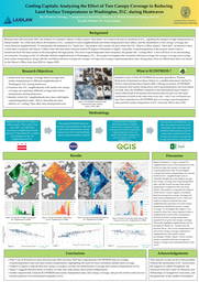
This research project utilizes data on average evapotranspiration rates and average land surface temperatures from ECOSTRESS (Ecosystem SpaceBorne Thermal Radiometer Experiment on Space Station)—a satellite attached to NASA’s International Space Station. Then, utilizing Quantum Geographic Information System (QGIS), I created spatial maps visualizing the average land surface temperatures, evapotranspiration rates, tree canopy coverage and evapotranspiration per canopy coverage for all neighborhoods in D.C. Lastly, I created scatterplots to visualize the correlation between such variables, while also determining the line of best fit and coefficient determination values.
By visualizing the correlation between average tree canopy coverage and land surface temperatures per D.C. neighborhood, this research aims to offer insight into which D.C. neighborhoods have the highest evapotranspiration rates and tree canopy coverage, while providing a starting point into understanding why certain neighborhoods in D.C. have similar land surface temperatures despite differing vastly in tree canopy coverage.
Primary objective: To assess how tree canopy coverage affects average land surface temperatures in different neighborhoods of Washington, D.C. during heatwaves.
Secondary objectives:
- To understand why D.C. neighborhoods with the same tree canopy coverage have different average land surface temperatures during heatwaves.
- Identify which D.C. neighborhoods have trees with higher evapotranspiration rates—in other words, trees that are more effective at “cooling” than other trees during heatwaves.
Background
Tree canopy coverage has historically been an integral part of urban planning in Washington, D.C. In 1872, D.C. gained the unofficial title of the “City of Trees” when Governor Alexander Shepherd directed 60,000 street trees to be planted in the nation’s capital. In the 1960s, First Lady Lady Bird Johnson created the “Committee for a More Beautiful Capital,” which helped improve D.C. parks by planting more trees. Fast forward to 2011, when Mayor Vincent C. Gray announced the "Sustainable D.C. Plan”—a planning effort to expand tree canopy coverage in the capital from 35% to 40% by 2032.
Such emphasis on tree canopy coverage can be attributed to trees’ regulatory services, such as trapping greenhouse gases, improving air quality, and reducing the urban heat island effect. Existing policy reports, such as the District of Columbia’s Urban Tree Canopy Plan, highlight that trees in D.C. can remove up to 490 metric tons of air pollution per year through carbon sequestration and the release of oxygen during photosynthesis.
Additionally, according to the U.S. Environmental Protection Agency, trees also cool cities by creating shade on sidewalks and reducing energy consumption in buildings. During the months of June to September, extreme heat days in D.C. can make it harder for children to learn, increase the risk of heat-associated mortality, and exacerbate the symptoms of those with pre-existing conditions.
My mentor—Dr. Taylor Jones—founded the Atmos Jones Lab, which uses custom sensors, complex models, and remote sensing data from satellites to better understand the dynamics of urban climate—including carbon emissions, extreme heat, and the role that trees play in climate systems. Through his expertise and mentorship, this project will utilize ECOSTRESS data and Geographical Information Systems to draw correlations between tree canopy coverage and land surface temperatures during heatwaves in Washington, D.C.
Methodology
This project will focus on D.C. heatwaves and ECOSTRESS data collected between June 2023 - June 2025.
To standardize the definition of a “heatwave,” this project will consider all days where the D.C. The Mayor's Office issued a “heat alert” for heatwave days. A heat alert is issued by the Mayor’s Office when the heat index forecast reaches 95 degrees Fahrenheit or higher. Notably, the heat index differs from air temperatures because it takes into account both temperature and humidity.
Generally, evapotranspiration is the process where water is transferred from the land surface to the atmosphere through plants. The more evapotranspiration that occurs, the greater the “cooling effect” on the surrounding environment. As such, I will use average evapotranspiration data and land surface temperature data captured by ECOSTRESS (Ecosystem Spaceborne Thermal Radiometer Experiment on Space Station)—a satellite instrument attached to NASA’s International Space Station—to map average evapotranspiration rates and land surface temperatures per D.C. neighborhood. Installed in July of 2018, ECOSTRESS is a relatively new Earth science instrument. Since the International Space Station orbits Earth at 90-minute intervals and does not pass over the same coordinates on Earth at the same time every day, we expect there to be gaps in our data collections, since there will likely be heatwave days in D.C. with no ECOSTRESS data available.
To define the perimeters of individual D.C. neighborhoods, I will download a neighborhood cluster map from “Open Data DC.” To visualize average tree canopy coverage, land surface temperature, evapotranspiration rates, and evapotranspiration rate per D.C. neighborhood, I will utilize the Quantum Geographic Information System (QGIS) to aggregate all the data. Finally, I will utilize Excel to create scatterplots, lines of best fit, and coefficient of determination values to analyze the correlation between average tree canopy coverage and land surface temperatures.
Potential Impact
The findings of this research could be useful to a broad range of audiences. From Washington D.C. policy makers, environmental think tanks, real estate companies, or D.C. residents. The primary goal of this project is to analyze the correlation between tree canopy coverage and land surface temperature during heatwaves in D.C. to encourage the planting of more trees. Moreover, patterns in data can also reveal neighborhood tree canopy coverage disparities. When correlated with socioeconomic data on poverty levels, disability rates, and racial demography, researchers can utilize findings from this project to draw broader inferences on environmental racism, the urban heat island effect, and make improvements to urban planning in D.C.
Resources & Support Needed: Access to official heat related hospitalization records in Washington, D.C. and a breakdown of different tree species in all 131 D.C. neighborhoods between June 2023 - June 2025.
I would like to thank Colleen Dougherty for assisting me and Dr. Taylor Jones for mentoring me throughout this research project. If you love trees or are interested in this research project please feel free to reach out to me at Fc689@georgetown.edu and follow along!
Hello! I am a junior in Georgetown University's School of Foreign Service studying Science, Technology, and international affairs with a minor in Australian, New Zealand and Pacific Studies.
As a Laidlaw scholar, I am working under the Atmos Jones Lab guided by Dr. Taylor Jones. My research utilizes ECOSTRESS data from the international space station and the Quantum Geographic Information System (QGIS) software to map average evapotranspiration rates and land surface temperatures in Washington, DC neighborhoods. The objective of this research is to understand how local DC communities can utilize ECOSTRESS data to combat extreme heat days.
Outside of Laidlaw, I am an implementation team member for the Global Governance Strategy for Planetary Health under the Helm Lab at Georgetown University. My research is focused on the role of the Commission of Small Island States on Climate change and International Law (COSIS) in reducing international law fragmentation.
In my free time I love spending time at the beach and exploring new places. I am an avid scuba diver and have had the opportunity to dive in 7 countries all over the Caribbean.
Please feel free to reach out to me here or at fc689@georgetown.edu !
Please sign in
If you are a registered user on Laidlaw Scholars Network, please sign in