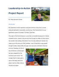
For my LiA project, I'll be working with Nortico Cacao Farm in Costa Rica! They focus on sustainable cacao production through their own farm and through the Soil Alliance, which supports local farmers in their cacao crops.
What went well?
I set up the drone owned by the farm since they had not been able to use it before and familiarized myself with it. Once that had been done, I started doing aerial imaging of the farm to develop a map. This required multiple flights given that the drone’s battery is short, and images must have a lot of overlap (~70%). I finished the week with all the imaging finalized, to start making the map this week.
On parallel to my main activities, I continued to collaborate with the farm staff in their daily activities as needed, such as tours or administrative tasks. This has brought me in the loop of the farm’s operations and now I feel much more part of the team. I also have taught farm staff to use the drone as I learned myself how to operate it, aiming for them to be comfortable in future imaging tasks.
What could have been done differently?
I could have explained more to farm staff and have better records of the task I was doing, for them to be better informed and to prepare them for future endeavors with other farmers, so as to ensure the continuity of the project. I’ll make sure to include all the necessary explanations in a briefing at the end of the project, but also make sure to do brief reports of my activities during the next weeks.
What did I learn about myself when working with others?
I learned that I am knowledgeable and proactive. I see that I am trusted by farm staff to do my own work and to seek collaboration when necessary, but I am also invited to help in other activities given my abilities. This has allowed me to contribute in different ways and to gain the trust of the staff.
What did I learn about leadership?
I learned that a leader has to be bold and creative in searching for solutions and ideas. I had not planned to do what I’m doing now, and I have some experience in mapping through courses but not with drone imaging. Nonetheless, I am undertaking this project because I trust that I can use my abilities to pull through, and I know it is a great way of advancing the use of digital tools in sustainable agriculture.
What do I want to develop or focus on next?
This week I’ll be focusing on developing the map and on thinking how to expand the mapping and data management tools to other local farmers. I want to focus on getting an initial product that I can adjust in the following weeks for better accessibility.
Hello there! I'm a third-year student in Conservation and Biodiversity at the University of Toronto Scarborough campus. My passion for biology stems from research on pollination, insects and biodiversity at my school's gardens since I was seven-years-old. Now, I intend to continue to pursue passion this with a project that has an impact in disadvantaged communities from my home country, Colombia.
I will be studying the pollination networks of cacao trees, which is crucial to contribute to agroforestry systems in tropical Latin America, so that they are a sustainable and productive opportunity for smallholder farmers that want to restore forest areas.
On a side note, I'm a curious person by nature and that's why I like to do and learn lots of things. So whether you are interested in my project or not, feel free to reach out! I believe that there are no boundaries when collaborating interdisciplinary. For example, research on cacao trees not only spans biology. There is ongoing anthropological research that is trying to figure out how cocoa got from the Amazon (its biological origin) to Mexico!
Please sign in
If you are a registered user on Laidlaw Scholars Network, please sign in